
Designing the future of NJ’s flood-prone lands
Rutgers ‘primer’ guides municipalities in how to protect themselves from rising waters

At the corner of Weber Avenue and Loniewski Street in Sayreville, empty brown lots sit between a quiet former residential street and a line of phragmites-choked wetland bordering the South River about a quarter-mile away.
The lots are the former sites of about 50 single-family homes that were flooded up to their second floors by Superstorm Sandy in 2012, and later purchased and demolished by Blue Acres, New Jersey’s state-run buyout program for willing sellers of flood-prone properties.
The land has sat empty since 2015, providing some resilience against storms and flooding simply by being devoid of dwellings. But that’s just tapping the beginning of its potential as part of the state’s barrier against flooding.
The 24 acres of land is limited as a defense against future floods by being former residential land with compacted soil and a meager variety of plants that would help absorb the deluges that are already coming with climate change.
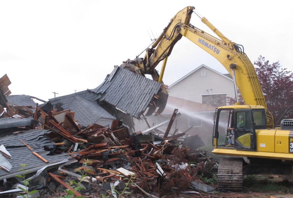
So the Borough of Sayreville is beginning to plant native grasses, wildflowers and shrubs at the site to help absorb future downpours and protect the neighborhood and downstream areas from flooding.
It’s just one strategy being mirrored across the state for Blue Acres properties, including in Linden, Union County, and at Money Island, Cumberland County, and now getting summed up in a new Rutgers University “primer” for all of New Jersey’s 564 municipalities on how to build flood resilience whether or not their lands have been vacated by Blue Acres demolitions.
A new how-to
The 94-page report, published last month, describes how local officials can build flood resiliency through measures such as rain gardens, permeable pavement, living shorelines and bioswales — open channels planted with a variety of vegetation that is designed to absorb floodwaters. The report was jointly written with the School of Design at South Dakota State University.
“I view it as a bit of a how-to, a bit of an empowering tool, and then a bit of a toolkit,” said Brooke Maslo, a Rutgers professor of ecology who leads the project, during a visit to the Sayreville site. “The reality is that we are not coming up with innovative tools; we are bringing it all together, and we’re putting it in a format that is sequential and digestible.”
Some of the work is already underway at towns across the state, according to Mike Cerra, executive director of the New Jersey League of Municipalities. He said awareness of the need to increase flood-resilience measures is widespread, and every municipality is pursuing at least one of the measures described in the primer.
But the technical advice, and the explanation of the need for such measures, are always welcome, especially for smaller towns, Cerra said.
“Certainly, the primer made available by Rutgers is going to be useful to a lot of municipalities. Technical guidance is always appreciated, especially in smaller municipalities, and a primer like this can be helpful to introduce our members to concepts and terminology they may not be familiar with,” Cerra said.
The extent of the measures being taken varies from town to town, and is often dependent on funding, he said, noting that towns are typically asked to “do more with less.” Although some funding is available from the DEP and the federal government, it is often highly competitive, and may not cover the entire cost of the project or may not be available throughout construction.
“A project may be eligible for a grant or could receive funding for the initial implementation or development but the continued availability of funding is an issue,” Cerra said.
Widespread adoption
The need for widespread adoption of flood-resilience measures is shown by New Jersey’s thousands of miles of rivers and coastline, and the heavy development of its land, where stormwater runoff increases exposure to flooding.
Some 630,000 properties across New Jersey have at least a 26% chance of being severely affected by flooding in the next 30 years, given its 1,800 miles of coastline and 6,450 miles of rivers, the Rutgers report said.
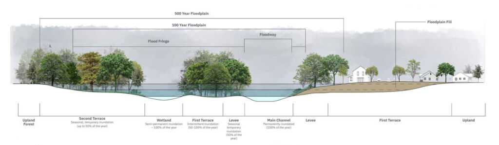
“Without ample natural ecosystems to absorb rainfall and runoff, even just a few inches of rain can cause flooding in many New Jersey communities,” it said.
The idea is the state buyouts of homes will help build resiliency by moving people out of harm’s way, demolishing their former homes, and building parks and wetlands on the newly vacant land to absorb future floods and protect adjacent neighborhoods.
‘What we are doing is embracing the fact that these landscapes are supposed to flood in significant events like that. When you allow that water a place to go then that means that downstream effects are less.
Brooke Maslo, Rutgers University
But it’s not always that simple. If the properties are bought with state or federal dollars, their future use is subject to deed restrictions that make it harder to install flood-control measures, the Rutgers report said.
Leaving the land to be maintained by measures such as mowing places a burden on municipal staff, while simply avoiding maintenance perpetuates the land’s reduced ecological function including reduced infiltration rates and flood-storage capacity.
“A ‘no-management’ option in many cases will provide little to no improvement in flood mitigation and can also contribute to negative perceptions about flood resilience initiatives,” it said.
That’s where the report comes in, suggesting resilience measures can also be adapted to flood-prone properties that have not been subject to state buyouts.
Seawalls not always the answer
One is Johnson Park in Piscataway, which is subject to flooding from the adjacent Raritan River, and which could be made more resilient by planting more vegetation and wetlands to absorb the river waters that currently spill across a wide area of the park when the river crests, Maslo said.
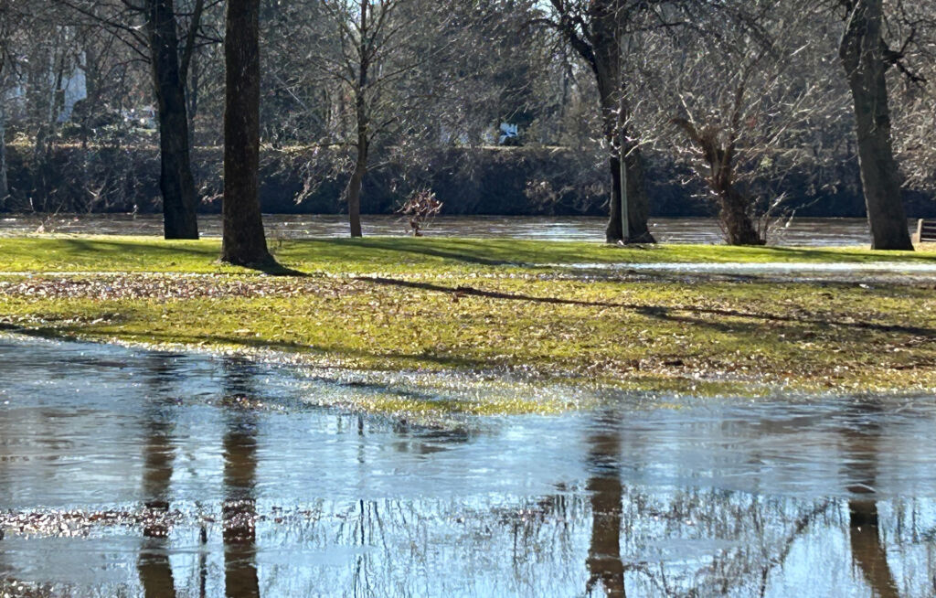
Throughout New Jersey, Maslo wants to help restore the ability of naturally flood-prone lands to cope with flooding after decades or centuries of development.
“This is not disaster avoidance; we are not building seawalls; we are not putting sheet piling in the ground,” she said. “What we are doing is embracing the fact that these landscapes are supposed to flood in significant events like that. When you allow that water a place to go then that means that downstream effects are less.”
The extent of Sayreville’s resilience project will depend on funding, and that will depend in part on whether residents support spending some of its open-space budget on improving Blue Acres lands.
Maslo said she’s not necessarily criticizing barriers such as sea walls, but is arguing that they are not infallible, and should be used in combination with landscape resilience.
“They are not appropriate in all situations,” she said of such physical barriers. “They work to their design-engineering specifications. The problem is that storms are predicted to exceed those. You have this false sense of security, you have a sea wall, but it didn’t do anything for you during Sandy.
“Once you exceed those specs, you are going to flood. Knowing where to put those things; understanding that they are not foolproof, and then allowing those places for the water to go where people aren’t going to get hurt, where emergency management isn’t going to have to do boat rescues — that’s the approach, an integrated approach.”
Matter of money in Sayreville
In Sayreville, business administrator Glenn Skarzynski said the project is a chance to reestablish nature in a way that will build flood resiliency while creating a recreational asset for the town.
Skarzynski, a former police captain who helped rescue Sayreville residents stranded by Sandy’s floods, avoided linking the project to climate change, but he said he welcomed the opportunity to create a natural haven in the flood zone.
“I’m not a climate scientist, and I will reserve my arch-conservative opinions with regard to that. But at the end of the day, anything that we do to improve nature for our residents is a plus,” he said. “At the end of the day those areas of our town are perfect for nature and ecosystem restoration. We have a moral obligation to do that because we live here.”
But it also requires money that Sayreville doesn’t have, at least not yet. The extent of Sayreville’s resilience project will depend on funding, and that will depend in part on whether the town’s approximately 45,000 people decide to support spending some of its open-space budget on improving the Blue Acres lands.
In November 2022, voters rejected a referendum question asking whether they wanted some of the open-space funds to be used for Blue Acres improvements. Skarzynski now acknowledges that he didn’t do enough to convince voters that saying “yes” to the question wouldn’t hurt their pocketbooks, and he promised to do a better communications job if the town council approves another referendum.
He predicted that voters would be more supportive of the question when they see the new plantings starting to emerge next spring on the land that has been empty for eight years. “My hope is that after we do this work, and people can see we are actually having a positive impact, I’m inclined to believe that we will have a better outcome at the referendum,” he said.
Lambertville’s plans
At Lambertville on the Delaware River in Hunterdon County, resilience measures are being explored for two properties where houses were destroyed during Tropical Storm Ida in September 2021, leading to their purchase and demolition by Blue Acres, said Andrew Nowick, the town’s mayor.

Nowick said the lots might become passive recreation spaces. With grant funding, they could be planted with native species.
“A lot of what we are working toward here in Lambertville is dovetailing with these suggestions,” he said, referring to the Rutgers report. “We are moving forward with resilience planning, and a lot of what’s in the primer is going to be very helpful to us.”
In the next six months or so, Blue Acres is expected to buy two more Lambertville properties that were badly damaged in Ida, and which are likely to be demolished, Nowick said.
The town is also working on setting up a stormwater utility — a financing mechanism that allows a town to charge a fee to all property owners, based on the amount of paved surface their property covers, and use the proceeds to fund stormwater control measures such as rain gardens or porous pavement.
Lambertville has now hired a consultant to do a feasibility study on setting up the utility. Nowick said he hopes to hold a referendum in November 2024 when voters will be asked whether they support the idea. If they do, the town would become one of the first in New Jersey to adopt a mechanism that is already widespread in other states.
In the last year, Lambertville won a $320,000 grant from the National Fish & Wildlife Foundation for “ecological uplift and stormwater attenuation” at a 9-acre property owned by the town. Nowick said there will be a strong focus there on resilience and green infrastructure such as rain gardens, planting native species and removing invasives.
Progress in Woodbridge
Similar improvements are already visible in Woodbridge, Middlesex County, where Sandy’s flooding led to the purchase and demolition of 172 houses, nearly all by the Blue Acres program.

The hardest-hit section of the town has become a meadow that was planted in November 2016 with warm-season grasses such as Indian grass and big bluestem, as well as wildflowers, milkweed, goldenrod and asters, all native to the northeastern United States, and all approved by the DEP.
Among the plantings are walking trails where houses once stood, accompanied by interpretive signs describing the birds of prey and other wildlife that can now be seen in the area where floodwaters were 5 or 6 feet above sea level during Sandy.
‘It’s not a retreat; it’s an attack on a problem. We’ve got to keep our heads down and keep moving forward, because the heavy-hitting storms are still coming.’
Tom Flynn, flood-plain administrator, Woodbridge
The work included the elimination of several unnatural 90-degree turns in a drainage ditch, encouraging the flow of water into a tributary of the Woodbridge River. The town also eliminated stands of phragmites, an invasive reed that now dominates many New Jersey wetlands, and replanted the area with native species.
Like Sayreville, Woodbridge also plans to remove some roads which contribute to flooding by preventing rainwater from soaking into the ground.
Open space
The DEP, which helped to pay for the Rutgers report, endorsed its conclusions.
“More New Jersey communities than ever before are grappling with severe flooding and looking for solutions for their flood-prone properties,” said Nick Angarone, DEP’s chief resilience officer.
“Landscape design is one option, and this primer will be invaluable to municipalities seeking to restore vacant land in a way that will enhance the resilience of the entire community.”
Just in Woodbridge and Sayreville alone, Blue Acres purchased 325 properties after Sandy at a combined total cost of $166.5 million in state and federal funds, the DEP said.
Although there have been no storms of Sandy’s magnitude since 2012, some nor’easters have tested the new resilience measures, and there has been no flooding of the area since Sandy, said Tom Flynn, Woodbridge’s flood-plain administrator.
“The town has created an open space conservation and resiliency zone,” he said. “Not only is it regulated by a flood-damage prevention ordinance. It’s also regulated by the fact that we’ve gone the extra yard to make it a conservation area where there are no new buildings.” Some existing buildings in the area are elevated.
Eventually, many predict that there will be full retreat from swollen rivers and their flooding as sea levels rise, and the concept has been a controversial one. But Flynn liked to think of what’s happening in his community as a more proactive step.
“It’s not a retreat; it’s an attack on a problem,” he said. “We’ve got to keep our heads down and keep moving forward, because the heavy-hitting storms are still coming.”
— Credit for opening image: Aerial photo taken on Oct. 31, 2012 shows destruction left in the wake of Superstorm Sandy in Seaside Heights, N.J. (AP Photo/Mike Groll)
