
 By Meteorologist John Cifelli
Last night was another record breaker in some parts of the state, and this cold snap can take the unfortunate moniker of “killer” cold, as at least three deaths related to exposure have been recorded. Statewide, high temperatures didn’t break 20 degrees, and some locations didn’t break into the double digits. Temperatures aloft have actually warmed all day today, but clear skies and no winds tonight means that this air mass will cool down to essentially as cold as it can be, as radiational cooling sends us back to near zero. The good news is that this will be the last night for the foreseeable future that is this cold.
The bad news is that warmer air comes in advance of our next winter weather event. What a surprise, it’s affecting New Jersey on a weekend. We certainly have seen our share of Saturday/Sunday winter weather over the past five weeks. A weak area of low pressure, currently sliding east from the central Rockies, will travel across the midsection of the country tonight and spread a healthy slug of moisture northward across the mid-Atlantic and Northeastern United States. Although the surface low is weak, the area of high pressure sliding off the East Coast currently is not, and so a switch to a light southerly wind tomorrow morning will help to gradually erode the cold air that has been entrenched in New Jersey for many days. Before this happens, snow will fall.
It will come in like a wall tomorrow from southwest to northeast, beginning in Salem County and the Philadelphia area probably a little before noon. By 3 p.m. it’s snowing just about everywhere in New Jersey, reaching New York City by dark. For a period, snow can fall heavy at times. Eventually warm air works in aloft to deteriorate snow growth conditions and reduce snowfall ratios (how many inches of snow falls relative to the amount of liquid H2O falls), and then we transition to sleet and possibly freezing rain, particularly in interior west/central New Jersey. When the changeover occurs is the million dollar question, as it will mean the difference between a couple slushy inches and a quick transition to plain rain, versus an extended period of heavy wet snow, ending as drizzle or snow showers.
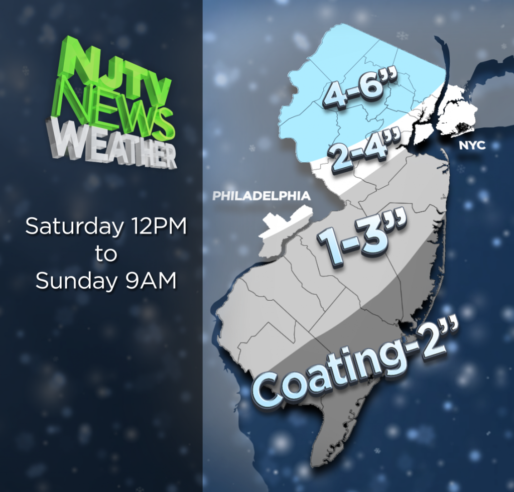
Right now I think except for far southeast New Jersey, we are going to see enough snow to cancel your Saturday evening plans. Expect a gradual changeover from I 95 north and west beginning around 8 or 9 p.m. Snow will transition to sleet or plain rain south of 195, but I am concerned about the potential for icing along a line between Trenton and Morristown and points west. Luckily, this falls for a couple hours near midnight, and by dawn, we’re dealing with plain rain. Ice accrual won’t be significant, but any time you are talking ice it bears concern.
North of 80, this is a mostly snow event.
I wouldn’t be shocked if someone in Warren, Morris, or southern Sussex County winds up with seven or eight inches, but four to six inches will be the norm for the northern tier this go around. We will lose some accumulation to poor ratios, and it might even look like less when you wake on Sunday if it gets rained on overnight. It will be a chore to shovel, that’s for certain.
Sunday we are seasonably cold, with some lingering snow showers or drizzle in the morning. Southern New Jersey particularly will hang onto the moisture a bit longer. Sunday night we return to a northerly flow and cold air returns. Monday night will again be single digit cold, before seasonable cold settles in for the rest of the week.